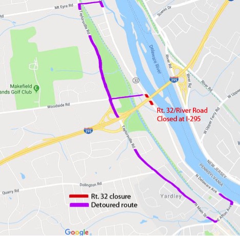
PA Route 32/River Road Near Scudder Falls Bridge to Close Weekdays Starting Wednesday, Oct. 3
PA Route 32/River Road in the vicinity of the Scudder Falls Bridge is scheduled to be closed 7 a.m. to 5 p.m. beginning Wednesday, October 3. The detour point south of the bridge will be at E. Afton Ave./N. Delware Ave. (Route 32) in Yardley. North of the bridge, detour points will be at Mt. Eyre Road (Upper Makefield/Lower Makefield) and Woodside Road (Lower Makefield). The travel restrictions are needed for the lifting and installation of 10-foot-tall steel girder beams for the new replacement bridge now under construction between recently completed piers on the Pennsylvania side of the river. The weekday closures are expected to continue until Oct. 12. A detour route map is below.
PA Route 32/River Road Detour Map
PROJECT OVERVIEW
Total Project Area: 4.4 miles along I-95 from Yardley-Newtown Road/Route 332 Interchange (Exit 49) in Pennsylvania to Bear Tavern Road/Route 579 (Exit 2) in New Jersey
Major Project Elements:
- Replace the current congestion-prone, functionally obsolete Scudder Falls Bridge with a dual-span structure carrying six thru-traffic lanes (three in each direction) and three auxiliary lanes (two northbound, one southbound) for traffic merging onto and off the bridge.
- Widen to the inside the bridge’s Pennsylvania I-95 approach, increasing the roadway to three lanes in each direction.
- Reconstruct the entire I-95/Route 29 Interchange (Exit 1) and its associated ramps and structures in Ewing, N.J.
- Reconfigure the I-95/Taylorville Road Interchange (Exit 51) in Lower Makefield, PA.
- Erect noise-abatement walls where warranted in Pennsylvania and New Jersey. (PA noise walls began in 2016)
- Improve/expand drainage and approach-roadway exit/entry transitions in New Jersey.
- Construct a pedestrian/bicycle walkway on the new bridge’s upstream side, connecting the recreational canal towpaths in Pennsylvania and New Jersey.
- Install an all-electronic tolling (AET) gantry and related infrastructure for highway-speed toll collection along the new bridge’s southbound lanes through E-ZPass tag readers and high-speed video cameras for license-plate billing.
- Mitigate environmental impacts from construction to protect shortnose sturgeon, red-bellied turtles, Indiana bats, yellow lampmussels, wetlands, and other natural and cultural resources.
Electronic Tolling Start (southbound only): Sometime in 2019.
Estimated Full Project Duration: 4-1/2 years
Learn More
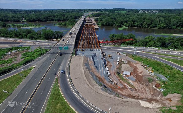
Project Progress Photos (click on photo below)
Project Progress Archives
